Village note
Runswick Bay, rebuilt after the cliff moved
Runswick lost most of its houses to a landslip and was built again on the same slope. What is there now, and why it sits like that.
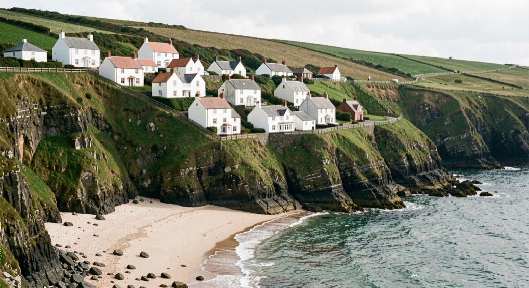
Runswick Bay is a bay, and a village perched on the western edge of it, 5 miles (8 km) north of Whitby, inside the North York Moors National Park. The village is the second one on this ground: the first was almost completely destroyed by a landslide in 1682 and rebuilt slightly to the south. This note sets out what the cliff did, why the place arrives in two halves, and what has since been spent to hold the ground in place.
The wake that saved the village
The original fishing village stood on the lower ground. In 1682 the cliff under it moved, and the settlement was almost completely destroyed. The alarm was raised by two mourners at a wake, and the village got out with no fatalities. The rebuilding was done slightly further south, perched on the side of the cliffs, and it is that red-roofed, stepped village that stands today.
A landslide that destroys a settlement without a single death is rare. What the account does not give is the hour, or the names of the two mourners.
Why does the village sit in two halves?
The lower village is the former fishing settlement: red roofs, narrow winding streets, steep steps, buildings packed tight against the slope. It is largely inaccessible to traffic; the only road in drops at a gradient of 1 in 4, and the uneven slopes make access difficult on foot as well. Above it sits Runswick Bank Top, a hamlet beside farmland overlooking the bay, built around the crossing of the roads to Ellerby and Hinderwell.
The two halves are joined by a steep lane, and the lane is part of the Cleveland Way, the national trail of 110 miles (177 km) between Helmsley and Filey. The trail reaches this shore at Saltburn and follows the cliff tops through Staithes, Runswick Bay and Sandsend before dropping into Whitby. The beach sits at the bottom of the lane. On UK road signs the name is often shortened to Runswick.
The boat that stayed behind
The village ran its own lifeboat from 1866 until 1978, when the boat was moved to the RNLI station at Staithes, up the coast. The boathouse stayed where it was. Since 1982 it has run its own volunteer rescue boat service, so the building on the shore still does the work it was built for. It keeps company with a thatched cottage, listed Grade II, among the few buildings of the lower village that can be picked out from the sands.
The headland that was mined
On the north side of the bay the cliff is called Cauldron Cliff. On the south side the headland is Kettleness, and Kettleness is a worked headland: alum was mined there from 1727 until the late 1800s. What that trade did to these cliffs is set out in the note on the alum coast. Between the two headlands lies the bay itself, 1.2 miles (2 km) long, with Runswick Sands, a white sand beach, running around its edge.
What comes out of the cliffs?
A series of caves opens around the bay. The largest is Hob Hole, named in local folklore for the hob, or boggart, believed to live there; the name records the belief, not a tenant. The cliffs erode fast along this coast, and that erosion is what makes the bay productive ground for fossil hunting, as the sea keeps cutting the rock back. Four streams drain into the bay across Runswick Sands, from west to east: Nettle Dale, Dunsley Dale, Calais Beck and Widgeytoft Gill.
How do you hold back a cliff?
The first answer was weight: a seawall of large boulders, completed in 1970. The second was money and engineering: a coastal erosion protection scheme costing £2.28 million, completed in 2018 and built to protect the village for another 100 years. The argument between the ground and the settlement runs through the whole record of the place.
| Year | What happened |
|---|---|
| 1682 | Landslide almost completely destroys the original fishing village |
| 1727 | Alum mining begins at Kettleness, on the south headland |
| 1866 | The village establishes its own lifeboat |
| 1970 | Boulder seawall completed |
| 1978 | Lifeboat moved to the RNLI station at Staithes |
| 1982 | Volunteer rescue boat service begins in the old boathouse |
| 2018 | £2.28 million coastal protection scheme completed |
Who lives in Runswick now?
In the late 1880s the village was the site of an art colony. The arrivals measured now are seasonal rather than resident: the village covers 620 hectares, holds a peak seasonal population of 2,315, and permanent residence is low, with a high share of houses kept as holiday lets and second homes.
The census figure of 1,875, taken in 2011, belongs to the parish of Hinderwell as a whole, not to the village, and should not be read as a headcount of Runswick. Part of the land in the village is owned by the Mulgrave Estate of the Marquess of Normanby. From 1974 to 2023 the place sat in the Borough of Scarborough; it is now administered by North Yorkshire Council.
What is standing now
Runswick Bay is a bay of 1.2 miles (2 km) on the North Yorkshire coast, 5 miles (8 km) north of Whitby, and a village of red roofs perched on its western edge, inside the North York Moors National Park. The parish is Hinderwell. What stands is the second village, rebuilt to the south after 1682: narrow streets and steep steps above the sands, the old lifeboat boathouse still crewed by volunteers, a thatched cottage listed Grade II, and a boulder seawall at the foot of it all. From Bank Top the joining lane can be seen dropping to the beach, with the Cleveland Way going down it, and the sands sit at the bottom of the lane.
The village’s shared year is the subject of the note on the village calendar, and the photographs and memories that record the landslip are the stuff of keeping local knowledge.
Runswick Bay keeps its houses close to the sea, with the road running tight against the wall and the beach a few steps below. Sandsend spreads itself along the valley instead, so the walk from door to sand is longer and the village feels less gathered. Inland towns work differently again. Alnwick sits behind its walls, and visitors there choose between a guest house and a self-catering cottage, with breakfast included in one and not the other. A plain guide to rooms in Alnwick sets out what each tariff covers.