Shore note
Sandsend beach, the scar and the cliff behind it
The beach that ends against a headland: what the sand, the ledges and the shale wall behind them actually are.
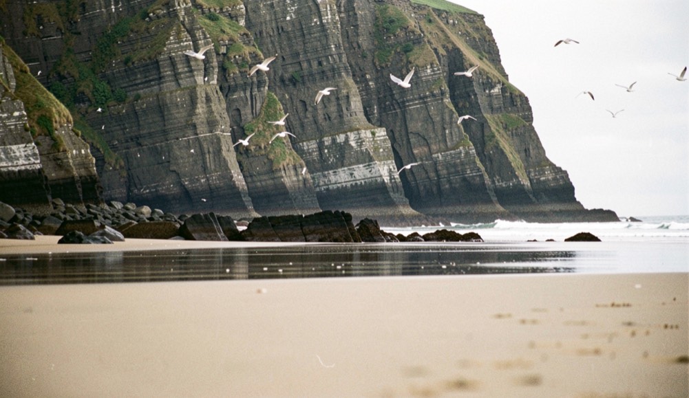
Sandsend beach is a piece of ground where three things meet: the sand that has run up from Whitby, two becks coming down from Mulgrave Woods, and the scar of rock that stops them all. This note reads that ground from the tideline upwards, to show what the cliff was made to yield, why the village at its foot is one place rather than two, and what now follows the course of the old rails.
Nothing in the reading is buried. The cement mill, the lime kiln, the two becks and the course of the lifted line can all still be found on the ground, and each of them answers for one layer of the village’s history. The note moves as the ground does: sand first, then stone, then rails.
Where the sand runs out
The long sweep of sand that starts at Whitby stops at Sandsend, against the cliffs. The village sits at that stopping point, a small fishing village in North Yorkshire within the civil parish of Lythe, the North Sea in front of it and rock above and behind. What reads on the map as one settlement began as two, Sandsend itself and East Row, and the join between them was made, in the first place, by cottages.
A large part of the western side of the village, the ground known as The Valley, still belongs to the Mulgrave Estate. One line often repeated about The Valley, that it is the dearest housing ground on the Yorkshire coast, circulates with no source attached; this notebook records it as a claim and no more.
Why is there one village and not two?
Sandsend and East Row began as separate villages, and they were joined when extra cottages were built for workers in the alum industry. The beach therefore carries a folded history: the sand is natural, the unbroken length of building behind it is not. A worker’s cottage is a small thing to alter a map with, yet that was the instrument that did it.
The labour came off the cliff. The note on the alum coast sets out how that ground was worked and what the working left behind; what matters on the sand is the demand for hands, and the houses built to keep those hands near the shore.
What the rock was wanted for
Alum is a hydrated double sulphate of aluminium, most often potassium alum, and for centuries it was the substance that made dye hold. It was the most common mordant in the dye industry, particularly in the Islamic world through the Middle Ages, and it served well beyond dyeing: in tanning, in the clarification of cloudy liquids, in medicine and cosmetics, in water treatment, in baking powder and pickling, and in fireproofing paper and cloth.
One British use reads oddly now. Alum preserved and bleached flour, and bakers worked small amounts of it into the fine white manchet bread made for the rich, adding more in poor harvests. In 1758 the British government banned alum from bread; the taste for the whiteness it faked outlived the ban.
The mill and the kiln that stayed
Two structures from the beach’s industrial past survive at the foot of the cliff: a former Roman Cement Mill with its mill house, and a lime kiln. The mill and its house hold an entry on the National Heritage List for England, numbered 1148893, under the parish of Lythe, and they sit inside a wider list of listed buildings in that parish. On a coast known for what was cut away from it, they are the fixed points.
Why were there viaducts over the sand?
Two becks empty into the North Sea at Sandsend, Sandsend Beck and East Row Beck. Both flow out of Mulgrave Woods before they reach the village, and anything built along this shore had to cross them rather than follow them. The railway was the thing built along the shore: it bridged both becks on high viaducts across the village, and it held that place from 1855 to 1958.
The line was the Whitby, Redcar and Middlesbrough Union Railway, and it buoyed the village with tourism for as long as it ran. Trains called at the station at Sandsend, which opened in 1883 and closed with the line in 1958. The viaducts are gone; the becks they carried the rails over still run.
The film that kept the station
The station has one surviving picture. The opening shots of Holiday Camp, a British comedy drama of 1947, show a train arriving at a cliff-top station and passengers boarding buses outside it, and those shots were filmed at Sandsend. The footage holds three things in one frame, the train, the station set at the top of the cliff, and the buses at its door. It is a thin record, but a moving one, and it fixes the station’s setting eleven years before the line closed.
The path that took the line’s course
Since 1969 the course of the old line north of the village has carried walkers rather than trains. The Cleveland Way, a National Trail of 110 miles (180 km) between Helmsley and the Brigg at Filey, was the second National Trail to open, and it is waymarked in both directions with the acorn symbol. From Saltburn it runs along the tops of the sea cliffs, through Skinningrove, Staithes, Runswick Bay and Sandsend, to Whitby; at Sandsend it follows the course of the old railway line northwards.
From the village the path goes on to Whitby, where it drops from the West Cliff, crosses the harbour by the swing bridge and climbs the steps to the abbey. The note on the Sandsend to Whitby stretch walks that ground in detail. The trail keeps to the North York Moors National Park apart from short sections, among them the stretch through Whitby itself.
A fishing village in the parish of Lythe
Sandsend is a small fishing village near Whitby, in North Yorkshire, England, and it forms part of the civil parish of Lythe. It is the birthplace of George Pyman, a shipping magnate who lived from 1822 to 1900. From 1974 to 2023 the village lay inside the Borough of Scarborough; it is now administered by the unitary North Yorkshire Council. Its western side, The Valley, remains largely with the Mulgrave Estate.
The whole of this note can be taken in from one stance. Stand where Sandsend Beck and East Row Beck cross the sand into the North Sea, and read the ground upwards: tideline, the cottages that joined two villages, then the course of the old line going north.