Moor note
Goathland and Beck Hole, above the Esk
A moorland village with sheep on the greens and a preserved station, and a hamlet in the valley below it at the foot of an old rail incline.
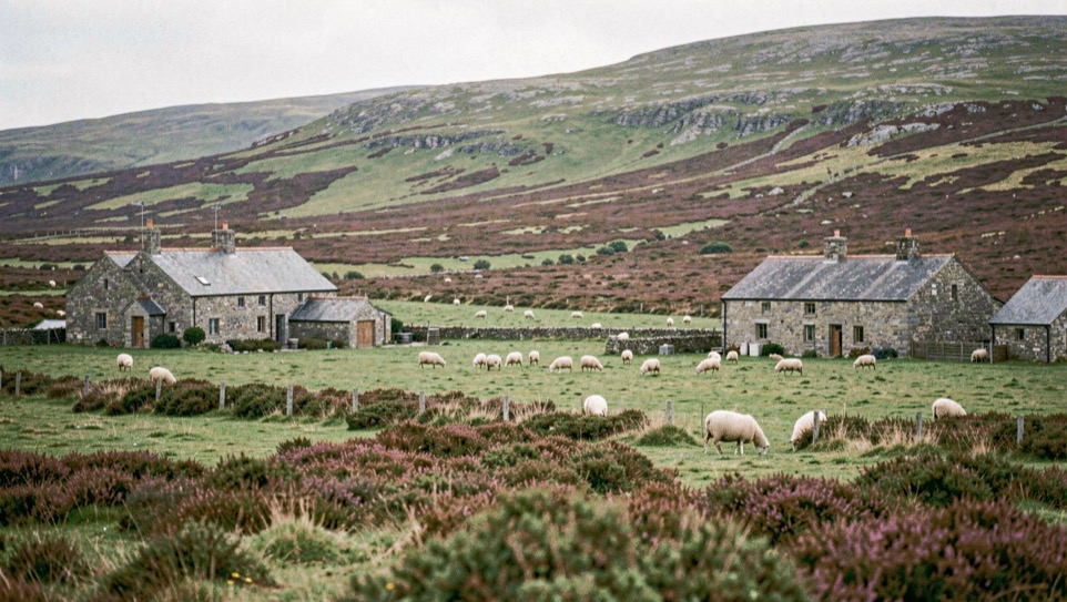
Goathland and Beck Hole are two settlements in one civil parish on the North York Moors: a village on the high ground, and a hamlet in the valley of the Murk Esk, joined first by a rope-worked railway incline, now by a footpath on the old trackbed. This note sets out what each place was for, what a failed ironworks did to the valley, and what is still standing.
Goathland sits at 486 feet (148 m) above sea level, off the A169 to Whitby and inside the national park; the 2011 census counted 438 people. Beck Hole lies about 1.25 miles north-west in the same parish, at roughly 70 m.
Good land, or Goda’s
Goathland’s recorded history reaches back to just after the Norman Conquest, though the settlement is absent from the Domesday Book. The name is probably a corruption of ‘good land’, or else ‘Goda’s land’, after an Old English personal name. In 1109 King Henry I granted land to Osmund the Priest and the brethren of the hermitage here, then called Godelandia, for the soul of his mother Queen Matilda; the charter is held at Whitby Abbey. The parish was remote enough in the 16th century for Elizabethan recusant Catholics to find safety at Hunt Hall on Wheeldale Moor; in the 19th century it took itself for a spa town.
Why is the station at the top of an incline?
The Whitby and Pickering Railway, planned by George Stephenson in 1831, arrived in 1836 with its Goathland station, Goathland Bank Top, at the head of an incline: carriages were drawn up from Beck Hole by a rope-worked drum. A deviation to Grosmont replaced the incline in 1865, a new station took the traffic, and Bank Top closed. The second station closed to regular passengers in 1965 and reopened in 1973 under preservation. The incline belongs with the paths and rails notes.
| Year | What happened |
|---|---|
| 1836 | Whitby and Pickering line opens; the incline is rope worked |
| 1865 | Deviation to Grosmont opens; Bank Top closes |
| 1951 | Branch into Beck Hole closes |
| 1965 | Regular passengers end in the Beeching cuts |
| 1973 | Grosmont to Pickering reopens, preserved |
Sheep, stone and the Duchy
Much of the land around the village belongs to the Duchy of Lancaster, whose tenants hold a common right, going back hundreds of years, to graze black faced sheep on the village green and the surrounding moorland. The green also carries the war memorial, sandstone, modelled on Lilla Cross, a waymarker on Fylingdales Moor 5 miles (8 km) east; it was grade II listed in November 2021.
St Mary’s Church went up between 1894 and 1896 and has been grade II* listed since 1969. A chapel had stood here since at least 1521, replaced by a church in 1821 whose stone was reused in other village buildings. Dressed stone was quarried locally and in short supply, fifteen years before the railway arrived.
What did the ironworks leave in the valley?
Beck Hole appears first as Amerholm, a single farmstead recorded in the late 16th century within the Forest of Pickering, which was cleared from the 13th century; a fulling mill worked at the river bank in the same period. In the late 1850s the Whitby Iron Company began extracting ironstone around the hamlet; two blast furnaces entered production in 1860, with a row of 33 cottages for the workers.
The works failed fast: a fault developed in one furnace, landslips hit a mine, the furnaces ceased in 1864, and after an 1888 sale the works and the cottage terrace were demolished. Community digs in 2017 and 2018 searched for what remains. The village that remained is small and mostly listed: 18th-century sandstone houses, a 19th-century stone bridge over the Ellerbeck, a 17th-century longhouse on the outskirts.
The line that came back
The preserved railway now runs 18 miles (29 km) from Grosmont to Pickering under a charitable trust, with some paid staff but mostly volunteers, nearly all year round, Christmas included. It carries more passengers than any other heritage railway in the UK, 355,000 of them in 2010; its rank is disputed, second-longest preserved line in Britain by one account, third-longest standard gauge heritage line by another. Since 2007 some services have run on to Whitby over the Esk Valley line, and a second platform opened at Whitby in 2014. Goathland station stood in for Hogsmeade in the Harry Potter films, and the 1995 film Carrington used the line too. The fuller record of Goathland gathers the figures and the film credits.
Aidensfield on television
Heartbeat, set in the 1960s, placed its fictional village of Aidensfield here, and many landmarks are recognisable, the shop, the garage and the station among them. The village has since turned up in Dan Chapman’s Closed Circuit (2014) and in Ice (2009), by Louis Nowra. Malcolm Saville’s Mystery Mine drew two maps of a partly fictional moorland around the village; Goathland, Wheeldale Moor and the Roman Road correspond to the real ground south of Eskdale.
Plough Monday and twenty apple trees
The Goathland Plough Stots perform a Long Sword dance every Plough Monday, in the village and around, raising money for local hospitals. The volunteer fire station is noted as the world’s smallest, housing a custom-built engine based on a Land Rover. The primary school holds 49 pupils and was rated good by Ofsted in 2013.
Down in Beck Hole, Victorian visitors came from miles around for the walks and the waterfalls, taking tea beneath the apple trees. Residents formed a woodland and heritage foundation in 2006 to protect the ancient woodland, and in 2009, for the school’s bicentenary, planted 20 heritage apple trees along the Rail Trail, each adopted by a schoolchild. One garden holds the survivor of a pair of Scots pines; the second was struck by lightning and burnt down before the 1900s.
The walk between the two
Goathland is a village and civil parish in the North York Moors national park, north of Pickering off the A169, with 438 residents at the 2011 census; from 1974 to 2023 it formed part of the Borough of Scarborough and is now run by the unitary North Yorkshire Council. Beck Hole shares the parish and lies about 1.25 miles north-west, down in the Murk Esk valley. The ground between them falls from 486 feet at the green to about 230 feet at the Ellerbeck bridge, steeply by road, gently on the old railway line.