Village note
Robin Hood’s Bay, poured down a ravine to the sea
The steepest village on this shore, built where a beck cut through the cliff, with a smuggling past and a rock ledge full of fossils.
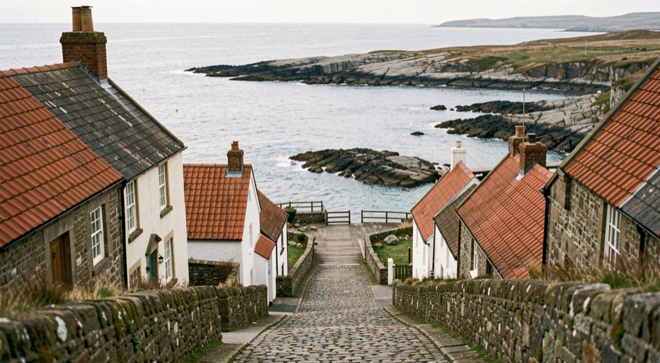
Robin Hood’s Bay is the village on this coast that had no choice about its shape. It sits in a fissure between two steep cliffs, six miles south of Whitby and fifteen miles north of Scarborough, and everything about it, the narrow main street, the cobbled slipway, the houses stacked shoulder to shoulder, follows that one fact. This note sets out where the village came from, what its people did for a living, and what a walker finds at the bottom of the hill today.
A name without an outlaw
The origin of the name is uncertain, and it is doubtful that Robin Hood was ever in the vicinity, if indeed he ever existed. The place is attested in the early sixteenth century as “Robyn Hoodis Baye” in 1544. An English ballad, The Noble Fisherman, tells of Robin Hood visiting Scarborough, working as a fisherman, defeating French pirates with his bow and spending half the loot on a house for the poor. The ballad is only attested from the seventeenth century at the earliest, and it is considered more likely an original work of that period than a medieval legend passed down.
Who was here before the village?
By about 1000, the neighbouring hamlet of Raw and the village of Thorpe, now Fylingthorpe, had been settled by Norwegians and Danes. After the Norman conquest, in 1069, much land in the north including Fylingdales was laid waste, and William the Conqueror gave Fylingdales to Tancred the Fleming, who later sold it to the Abbot of Whitby. The settlements then sat about a mile inland at Raw. The earliest reference to the bay itself by name comes in the period 1324 to 1346, when Louis I, Count of Flanders, complained in a letter to Edward III that Flemish fishermen, with their boats and catches, had been taken by force to Robyn Oeds Bay. By about 1500 a settlement had grown on the coast.
The antiquary Leland mentioned “Robin Hoode Baye” in 1536 and described it as “A fischer tounlet of 20 bootes with Dok or Bosom of a mile yn length”. After the Dissolution of the Monasteries in 1540, Whitby Abbey and its lands passed to Henry VIII; King Street and King’s Beck in the village date from that time. In the sixteenth century this was a more important port than Whitby, and Waghenaer’s North Sea charts of 1586, now held in Rotterdam’s Maritime Museum, mark it with a tiny picture of tall houses and an anchor.
Why did the smugglers like it?
The village is a maze of tiny streets, and there is reputed to be a network of subterranean passageways linking the houses. In the late eighteenth century smuggling was rife along the Yorkshire coast: vessels from the continent landed contraband financed by syndicates, who took the profits while seamen and villagers took the risks. Tea, gin, rum, brandy and tobacco came in from the Netherlands and France to avoid duty. In 1773 two excise cutters, the Mermaid and the Eagle, were outgunned and chased out of the bay by three smuggling vessels, a schooner and two shallops. In 1779 a pitched battle between smugglers and excise men was fought in the dock over 200 casks of brandy and geneva and 15 bags of tea. The Wikipedia entry on Robin Hood’s Bay gathers these episodes in full, along with the geology and the place in literature.
Cobles, panniers and the long walk to York
Fishing and farming were the original occupations, and many houses in the village were built between 1650 and 1750 by families who owned or part-owned cobles. Fishing peaked in the mid nineteenth century: cobles were used for line fishing in winter, larger boats for herring. Fish was loaded into panniers, and men and women walked or rode over the moorland tracks to Pickering or York. The decline began in the late nineteenth century, and today most of the village’s income comes from tourism.
One plaque in the village records what the fishing life cost. On 18 January 1881, during a violent storm, a brig named Visiter ran aground. The Whitby lifeboat was pulled six miles overland by 18 horses, with 200 men clearing snowdrifts seven feet deep; men went ahead demolishing garden walls and uprooting bushes so the carriage could pass the narrow, awkward bends. Launched two hours after leaving Whitby, it rescued the crew on the second attempt.
What the cliffs are made of
The houses are built mostly of sandstone with red-tiled roofs. The main street, New Road, descends from the cliff-top, where the manor house and St Stephen’s Church stand, crosses King’s Beck and reaches the beach by a cobbled slipway known as Wayfoot, where the beck discharges onto the shore. The cliffs are Upper Lias shale, capped by Dogger and False Bedded Sandstones and shales of the Lower Oolite. The Wine Haven Profile near the village is the Global Stratotype Section and Point of the Pliensbachian Epoch, 183 to 189.6 million years ago, one of four chronographic substages of the Early Jurassic.
Fossils are part of the village’s ordinary furniture. The foreshore rocks on the north side of the bay are a well known location for ammonites, especially after winter storms, when the sea strips the shale and leaves the beds clean. In 1912 Professor Walter Garstang of Leeds University, with Professor Alfred Denny of Sheffield, established a marine laboratory here; it ran on the same site for 71 years, closing in 1983.
The railway that came and went
The village was served by Robin Hood’s Bay station on the Scarborough and Whitby line, which opened in 1885 and closed in 1965. The old track is now a footpath and cycleway, part of the Cinder Track, which links Whitby and Scarborough and forms part of National Cycle Route 1. The notes on the Cinder Track cover that line in detail; the nearest railway station today is at Whitby, and the X93 bus between Scarborough and Middlesbrough passes through hourly.
Two long walks meet here. The village is the eastern terminus of Wainwright’s Coast to Coast Walk from St Bees Head in Cumbria, and it stands on the coastal section of the Cleveland Way, which runs 110 miles from Helmsley to Filey. The stretch that comes down from Whitby is described in the note on the Cleveland Way cliffs.
Robin Hood’s Bay in books and film
The village is the setting for Leo Walmsley’s Bramblewick novels, among them Three Fevers, Phantom Lobster and Sally Lunn; Walmsley, who lived here between 1894 and 1913, was educated in the schoolroom of the old Wesleyan Chapel in the lower village. The 1935 film Turn of the Tide was based on Three Fevers and filmed in the village.
Stand at Wayfoot at low tide and look north along the foreshore; the ammonites sit in the Upper Lias shale, and winter storms renew the supply.